
Their novel monitoring system can rapidly monitor carbon dioxide sequestered underground.
Capturing and storing carbon dioxide (CO2) deep underground can help combat climate change, but long-term monitoring of the stored CO2 within a geological storage site is difficult using current physics-based methods.
Texas A&M University researchers proved that unsupervised machine-learning methods could analyze the sensor-gathered data from a geological carbon-storage site and rapidly depict the underground CO2 plume locations and movements over time, lowering the risk of an unregistered CO2 escape.
Project lead Siddharth Misra, the Ted H. Smith, Jr. ’75 and Max R. Vordenbaum ’73 DVG Associate Professor in the Harold Vance Department of Petroleum Engineering, used seed money from the Texas A&M Energy Institute to begin the research.
“The project was designed to facilitate long-term CO2 storage at low risk,” said Misra. “Current physics-driven models are time consuming to produce and assume where the CO2 is in a storage site. We are letting the data tell us where the CO2 actually is. We are also providing rapid visualization because if you cannot see the CO2, you cannot control it deep underground.”
Increasing levels of CO2 in the atmosphere raise global temperatures because the gas absorbs heat radiating from the Earth, releases it back to the Earth over a long time and stays in the atmosphere far longer than other greenhouse gases.
Since more CO2 exists than can be easily filtered out by Earth’s natural processes, it’s essential to keep it out of the air by other means. Sequestering the unwanted gas underground isn’t new, but monitoring its presence within a geological site is challenging because CO2 is invisible, quickly moves through cracks and escapes without detection.
Current, physics-driven models rely on statistics or numerical calculations that match known physical laws backed by research results. However, the latest geological sensors yield an enormous amount of data suggesting a lot of variety exists in subsurface compositions than was previously thought. Physics-driven models don’t include the information because such variations aren’t fully understood, but Misra knew that data contained knowledge useful to the situation.
Misra and Keyla Gonzalez, his graduate researcher, began by showing where the CO2 was spatially. Since the entire subsurface data set had to be mined for clues, they used unsupervised machine learning to locate the CO2. Unlike supervised machine learning, where computer algorithms are taught which data will answer a specific question, unsupervised learning uses algorithms to sift through data to find patterns that relate to the parameters of a problem when no definite answers to a question exist yet.
First, the algorithms assessed the presence of CO2 in the data using five broad or qualitative ranges, from very high concentrations down to zero traces of it. Colors identified each range for a 2D visual representation, with the brightest color for the highest content and black for no CO2. These generalizations sped up pinpointing the plume’s location, how much area it covered and its approximate size, shape and density.
The algorithms learned several workflow methods to read data and model the CO2. Misra and Gonzalez couldn’t rely on only one method to find the “right” answer because using unsupervised learning meant no real solution to the problem existed yet. And any answer found would have to be confirmed rigorously, so each answer was compared against the others. Similar results proved the solutions were unique to finding only the CO2, no matter which methods were used.
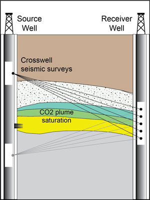
More data was needed to track the movement of the CO2 through time, so the algorithms were taught to sift through and evaluate data in different formats, such as crosswell seismic tomography. Because the algorithms were already geared to a purely data-driven approach and visualized on a general level, the spatial-temporal maps were quickly generated no matter what information was used. Again, similar results proved the researchers were on the right track.
Misra and Gonzalez published a paper on the research in the journal Expert Systems with Applications. Gonzalez has graduated and took a position with TGS, an international energy data and intelligence company that was impressed with the work.
“The next step will be the combination of rapid prediction, rapid visualization and real-time decision making, something the U.S. Department of Energy is interested in,” said Misra. “Even though the work was hard and required a lot of confirmation to validate, I can see so much potential in research like this. Many more applications and breakthroughs are possible. Unsupervised learning takes more effort but gives so much insight.”
This article was written by Nancy Luedke and first appeared at https://engineering.tamu.edu/news/2022/04/pete-research-accurately-monitors-subsurface-carbon-dioxide-storage.html.